Section 2.4
Build Resource Database
SECTION 2
Knowledge Gathering
Take stock of the resources in your community that are relevant to food insecurity. Not only will this give you a repository of available resources, it will also show where the current gaps in your community are and help prioritize your project’s work to fill those gaps.
Identify assets
Create a database of existing resources within the community, including grocery stores, resource centers, food pantries and shelves, schools, convenience stores, nonprofits, Social Security and SNAP offices, among others.
For each of these categories, gather all the locations included within your covered area and collect key details including opening hours, address, website and contact information. This is the first step in the asset mapping process and will enable the project team to have a good understanding of the assets in the region and how to tap into them later on.
“A huge part of creating a coalition is just getting everyone on the same page, getting all the info in one place that people can use. I’ve worked for the county for seven years and through the coalition I learned about resources that I never even knew existed.”
Financial Assistance Supervisor, Mower County Health & Human Services
Getting a complete picture of hunger in your community requires more than just knowing what the food insecurity rate in your community is. You want to figure out why it is and how to reduce it.
Master Resource Database
Creating a master database of community resources was more difficult than we expected, but we uncovered and were able to share lots of details that not everyone was aware of.
We started by creating a shared Google Sheet with all of the resource information. We had more than a dozen categories, including but not limited to food pantries, donation sites, schools, food stores, resource offices and community meal sites. We found this useful as a basis for:
- Adding information to our website and mobile app
- Creating flyers and other materials
- Analyzing hours and locations of open food pantries, and gaps
- Importing into our customer relationship management (CRM) database for future contacts
We suggest appointing a database czar to ensure that this resource always has the most up-to-date information, and noting when updates are made to each item, and by whom.
| Resource Category | X loc | Y loc | Type | Street Line 1 | Street Line 2 | City | State | Zip Code | Days / Hours | Website | Other Details | Contact |
Mapping Insights
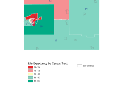
We found that using maps to compare different aspects of the community provided a better understanding of the various factors at play: demographics, poverty rates, transportation, education and institutions. It was then critical in helping us identify gaps in current resources and opportunities for action.
Here are ways we used mapping in the Mower County Community Assessment Report to help identify opportunities and gaps and help tell a story:
- Mapping the food insecurity rate of each town in our community
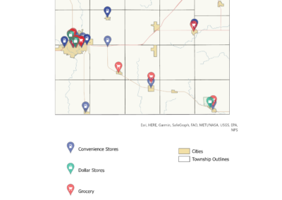
- Plotting the locations of grocery stores to identify food deserts
- Mapping unemployment rates across the county
- Marking locations of all available food resources (grocery stores, markets, food pantries, resources centers, etc.)
When mapping the food shelves, pantries and community meals sites, we noticed that there were large geographic gaps. This observation motivated us to create a mobile food pantry.
Mapping Tools
We used ArcGIS for our mapping projects: ArcGIS provides data integration, visualization and storytelling capabilities that your coalition can use to display important aspects of your coalition’s community. This worked very well, but we were fortunate to have a coalition member with an account and team that were proficient in using it. Some academic institutions allow free access for their students. Otherwise, organizations may have to pay a small fee, and there are other tools that you can use.
It should be noted that these platforms require some training and tutorials to be able to use them competently, especially if you don’t have prior experience with GIS (graphic information system) software. Most platforms include tutorials that can help you get started.
Capacity Builder: This USDA tool makes it very easy to map local measures related to food security and may be the best starting point. Just zoom and click layers on and off.
QGIS: A free, open-source alternative to ArcGIS that provides a wide range of mapping and spatial analysis features. It is highly customizable and supports numerous data formats.
GRASS GIS: Another open-source GIS software, GRASS specializes in geospatial data management, analysis and visualization.
Google Maps: Create custom versions and layers on Google Maps. Best for mapping points, like grocery stores vs schools. Harder to overlay topical areas. You can use Google Maps to easily find x,y (latitude/longitude) coordinates as well.
Better Understand Local Hunger and Food Insecurity
“If you don’t measure it, you don’t know if it’s good or bad. And if you don’t know if it’s good or bad, you don’t know what resources or strategies to apply to it. It has been really impressive to watch the coalition focus on the data gathering piece to understand and get at the root cause of some of these issues. For us personally, it’s been eye-opening. The simple thing is people don’t have enough food, but what you learn is there are so many different causes as to why community members don’t have the food they need. Once you know those reasons, you can start to direct actions against that.”
Hometown Food Security Project founding member and community advocate
Critical Factors in Your Community
The USDA defines food insecurity as the lack of consistent access to enough food for an active, healthy life, ranging from limited access to nutritious foods to experiencing hunger due to food scarcity. While poverty is a key factor, food insecurity is complex and varies by community, influenced by issues such as disabilities, job loss, immigration status and incarceration. This variation highlights the importance of a localized approach to addressing hunger effectively.
Understanding the unique causes of food insecurity in your community is essential for effective outreach, solution implementation and measuring success in closing the hunger gap. Understanding these social determinants of health provides a comprehensive view of the challenges a household may face, allowing for more effective and targeted interventions.
Identifying Resource Gaps
Every community has resources for the food insecure. In Mower County, we identified dozens of organizations and agencies that address food insecurity in some manner. However, within that web of support we found gaps and limitations that needed to be addressed. These included language barriers, transportation access and restrictions on access to governmental assistance due to income cut-offs and citizenship status. Identifying these gaps and limitations helped the coalition focus its attention and resources.
Downstream Effects of Food Insecurity
Food insecurity has far-reaching consequences for both individuals and communities. For individuals, it leads to poor physical and mental health, including malnutrition, chronic illnesses and heightened stress and anxiety. Children in food-insecure households often experience developmental delays, academic struggles and behavioral issues. Communities suffer as food insecurity contributes to higher healthcare costs, reduced workforce productivity and increased strain on social services. About eighty-five percent of U.S. healthcare spending is tied to diet-related chronic diseases, conditions often rooted in food insecurity. Additionally, it can perpetuate cycles of poverty and inequality, weakening social cohesion and resilience, and hindering overall community well-being and economic growth. Where do you see the downstream consequences of food insecurity in your area?


